Manage mid-story fuel loads to reduce fire damage in timber stands
Consider longleaf pine as the most resilient pine to wildfire damage
This blog post is to remind owners about the catastrophic damage done during the 2011 Bearing Fire in Polk and Trinity County and to discuss ways to develop pine stands that withstand wildfire damage.
Landowners in Texas can reduce their risk of wildfire damage to their timber by removing volatile fuels in their stands. We think of the extreme drought and high temperature of 2011, but fires kill pines in seasons of normal weather conditions when the stand’s structure is not managed to survive a wildfire.
Almost all the historic longleaf forest in southeast Texas has been converted to short rotation loblolly plantations. The Texas Longleaf Taskforce has been helping owners to reestablish longleaf, but the total acreage is still less than 50,000 acres of longleaf. The former longleaf forests were typically resilient from the natural fires that burned their grassy groundcover at two to five year intervals. However, any pine forest can be damaged if it gets burned when it has a thicket of understory yaupon draped with pine needles. Longleaf is susceptible to fire mortality if burned when the terminal bud is extended beyond its protective sheath. Ground fires can spread upward into the canopy if there is a ladder of combustible fuel and kill large trees. One of the best ways to reduce the intensity of a fire in pine farms is to remove the mid story brush with herbicides, mulching, and/or prescribed burning.
Mid story shrubs such as yaupon will not be killed with one treatment of herbicides or prescribed burning. Well established yaupon may need multiple efforts over time to reduce yaupon to knee high. Once the brush is controlled, light entering the stand will allow grasses and forbs to respond. Grass response will also be enhanced when the pine stand is thinned.
Consider using prescribed fire at two to three year intervals to maintain a grassy ground cover, control yaupon and consume accumulated natural fuels. Developing the appropriate sequence of prescribed burning, thinning, and herbicide use is best planned by a skilled forester and not attempted after a shallow study of the subject.
Longleaf pine has a unique growth form that protects the terminal bud most of the year from fire. Longleaf tolerates fire better when that sheath of needles wraps around the bud. Loblolly do not have that adaptation. Shortleaf has an advantage over loblolly in that they can sprout back as seedlings from their roots. However, all pines can be killed by fire if the plantation contains thickets of dense yaupon.
Consider the natural distribution of longleaf pine in east Texas on its western edge as shown on the map done by Little in the early 20th century. In addition to these early mapping efforts, we have records of old longleaf west of the Trinity River and on the National Forest north of the mapped boundary. The maps produced between 1900 and 1930 are helpful to see where longleaf historically dominated about 2 million acres of east Texas. Longleaf ranges across the southern states coincided roughly where summer lightning fires were common. This is also where you can still find remnants of fire adapted plant communities that developed under a one to three year interval of fire occurrence for thousands of years.
So, back to 2011, the most severe drought in Texas in recorded history. Many of us have experienced hot, dry years in Texas. I lived in Dallas in the 1950s drought when the city pumped water from the Red River (https://www.texasmonthly.com/articles/when-the-sky-ran-dry/).
I lived in Decatur and helped manage the LBJ National Grasslands in 1980 when we had 60+ days over 100 degrees. Extreme heat and low rainfall killed trees even without fire (https://www.dallasnews.com/news/2010/08/06/dallas-fort-worth-heat-wave-of-1980-still-seared-into-memories/).
In 2011, east Texas wildfires killed thousands of acres of valuable loblolly timber stands on the historical range of the longleaf pine. Two examples of east Texas fires from the summer of 2011 offer valuable experiences for landowners wanting to protect their timber portfolio from future fires.
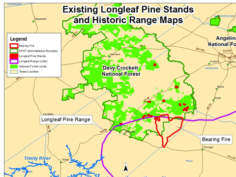
The outline of the “Bearing Fire” (red polygon) overlays the historical range of longleaf (purple line). In the summer of 2011, most of the private timber land in Polk and Trinity Counties was in short rotation loblolly plantations. Typically, the plantations were not in a prescribed burning program and had accumulated a heavy fuel load of yaupon and pine needle drape on the understory shrubs.
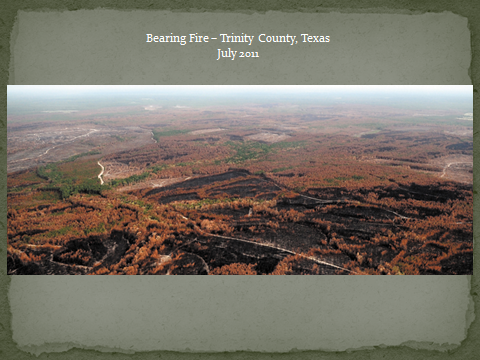
The fire started on June 17, 2011 along highway 287 in Polk County and burned north into Trinity County. Most of the 20,000 acres burned in three days. The photo above is a view of a portion of the Bearing Fire looking north toward the Davy Crockett National Forest, two weeks after control. The dense mid-story of yaupon allowed the fire to crown into the loblolly and run rapidly across the landscape. This type of fire behavior is not stopped with dozers or aircraft until there is a change or break in the fuel type or a change in the weather. Texas A&M Forest Service reported the loss as 21.4 million to 30.6 million cubic feet of timber destroyed worth $12.8 million to $18.3 million (Texas Wildfires 2011, texasfirewise.org).
The fire was contained along a state highway and on the Davy Crockett National Forest. Control was aided when the fire entered a timber stand that had some prescribed burning, a much lower fuel load, and along fire control lines installed a few months earlier. The U.S. Forest Service prescribed burning at three to four year intervals had not fireproofed the stand of loblolly (450 acres of loblolly age 50 to 70 years). The U.S. Forest Service documented 220 acres with 100 % mortality and scattered mortality of the other 230 acres.
The burned area on the National Forest was replanted to longleaf pine in the winter of 2011/12. The new longleaf stand has been prescribed burned twice since planting.
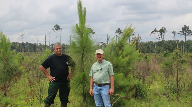
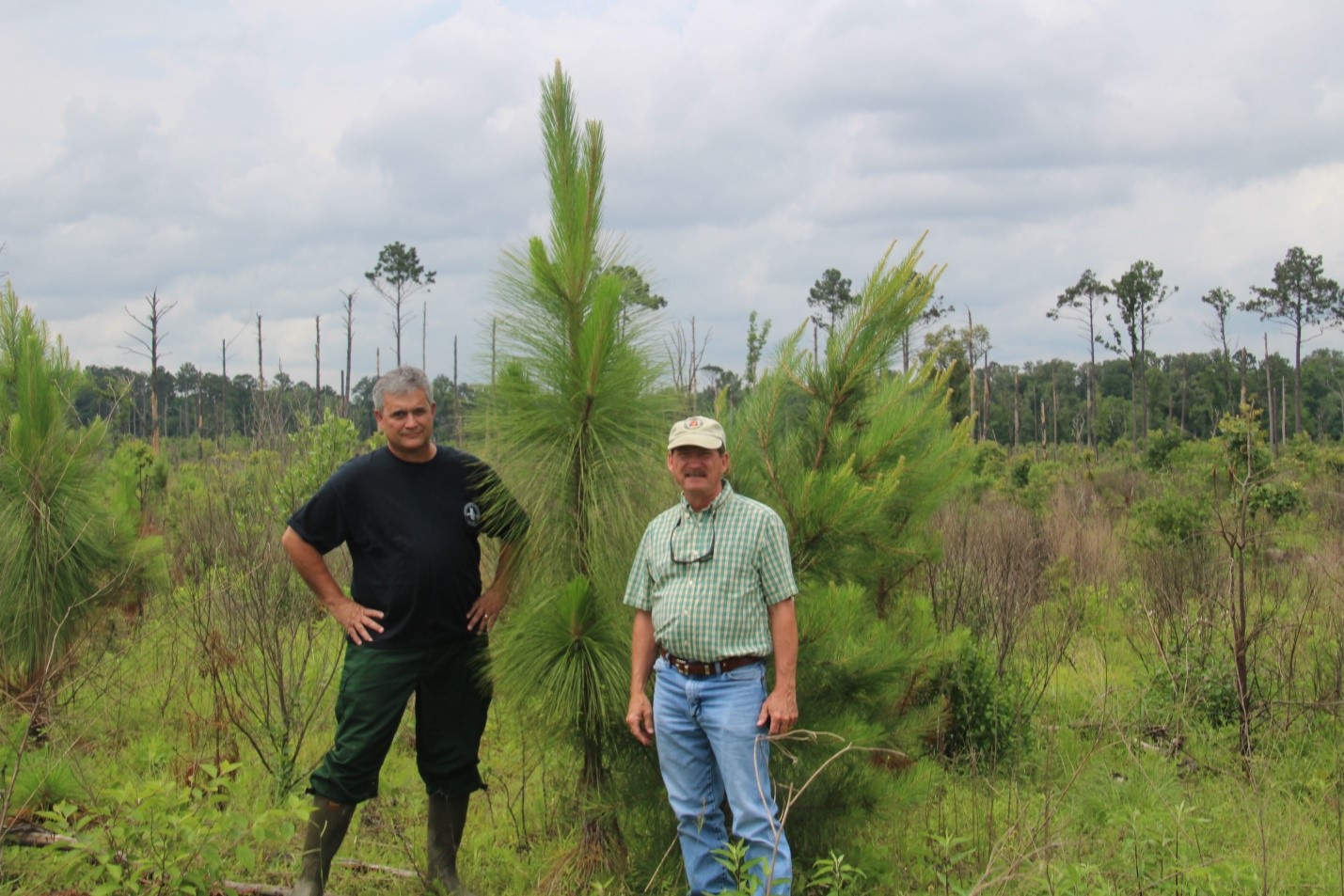
The Cypress Fire is an example of the fire resistance of a 11 year old longleaf pine plantation
Let’s look at another fire, also in 2011, on the Angelina National Forest east of Zavalla. Although Texas supported almost 2 million acres of longleaf prior to 1900, less than 50,000 acres are now growing in that range. Most of it is found on the Angelina and Sabine National Forests, east and south of Lufkin, Texas.
August 2011 was a continuation of the extreme drought and heat conditions persistent in east Texas. On August 24th, U.S. Forest Service fire crews were responding to several new fires in east Texas covering several hundred acres on the Angelina and Sabine National Forests. One of the ignitions on that day was named the Cypress Fire. This fire was east of Zavalla and started as a spot fire from a larger fast-moving fire north of Corinth Church. I was serving as the Fire Staff Officer for the National Forests in Texas. I met the Angelina National Forest Fire Management Officer, Jamie Sowell, on the fire. We were parked in the highway discussing fire attack plans when the fire jumped the highway and ran south toward a young longleaf plantation. Jamie assigned Dale Snyder as the Incident Commander. It was a busy day for us all, so I did not get into the plantation to take photos until a few days later. I recall thinking that this could be a very good test of longleaf resistance to the catastrophic burning conditions in Texas in August 2011.
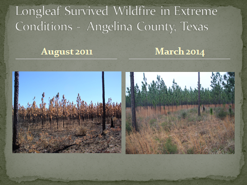
The initial appearance of the burned longleaf plantation was catastrophic, with possible mass mortality. However, the U.S. Forest Service prescribed burn program had modified the stand structure of this plantation as it matured and allowed it to develop some fire resistance. By burning this stand at two to three year intervals, a thick yaupon mid story did not develop. Without the woody, highly flammable yaupon, the fire did not have intense heat up in the canopy near the terminal buds. The primary fuel in this longleaf plantation was the herbaceous understory of grasses and forbs, three to four feet high. The fire running through those light surface fuels was well tolerated by longleaf.
In the attached photo pair (2011-2014), note the grassy understory and a few scattered yaupon. On the day of the wildfire, the plantation had one year’s worth of accumulated fuel load, primarily longleaf pine straw and perennial bunch grass, e.g. little bluestem. Observations from the day of the fire at 4 pm was a temperature of 102 degrees, 10 hour fuel moisture 5%, Keech Bryam Drought Index* 780, and wind N @6 mph. The running fire had 20 foot flame lengths with the frontal passage, then an abrupt temperature drop to 83 degrees at 6 pm. This photo was in the most intensely burned portion of the 153 acres of burned longleaf plantation. The photo is typical of the survival across the stand, with no mortality visible 18 months after the wildfire.
*KBDI defined, U.S. Forest Service (note that the index only goes to 800):
Keetch and Byram (1968) designed a drought index specifically for fire potential assessment. It is a number representing the net effect of evapotranspiration and precipitation in producing cumulative moisture deficiency in deep duff and upper soil layers. It is a continuous index, relating to the flammability of organic material in the ground.
The KBDI attempts to measure the amount of precipitation necessary to return the soil to full field capacity. It is a closed system ranging from 0 to 800 units and represents a moisture regime from 0 to 8 inches of water through the soil layer. At 8 inches of water, the KBDI assumes saturation. Zero is the point of no moisture deficiency and 800 is the maximum drought that is possible. At any point along the scale, the index number indicates the amount of net rainfall that is required to reduce the index to zero, or saturation.
The inputs for KBDI are weather station latitude, mean annual precipitation, maximum dry bulb temperature, and the last 24 hours of rainfall. Reduction in drought occurs only when rainfall exceeds 0.20 inch (called net rainfall). The computational steps involve reducing the drought index by the net rain amount and increasing the drought index by a drought factor.
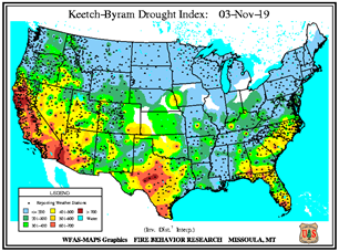
- KBDI = 0 - 200: Soil moisture and large class fuel moistures are high and do not contribute much to fire intensity. Typical of spring dormant season following winter precipitation.
- KBDI = 200 - 400: Typical of late spring, early growing season. Lower litter and duff layers are drying and beginning to contribute to fire intensity.
- KBDI = 400 - 600: Typical of late summer, early fall. Lower litter and duff layers actively contribute to fire intensity and will burn actively.
- KBDI = 600 - 800: Often associated with more severe drought with increased wildfire occurrence. Intense, deep burning fires with significant downwind spotting can be expected. Live fuels can also be expected to burn actively at these levels.
**Disclaimer: The views expressed in blog posts on txlongleaf.org are those of the author.